

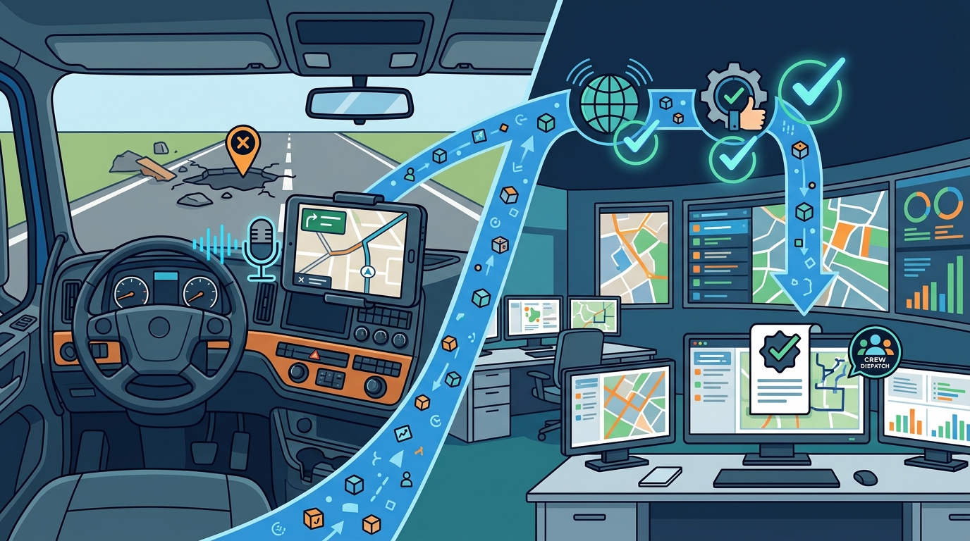
Hands-free navigation integrates verified reporting by using voice commands to capture road hazards and automatically validating that data against GPS coordinates and user history. This process ensures that only accurate, actionable reports reach municipal maintenance teams. This guide explains how WhereY'at Inc. connects drivers with infrastructure managers through a seamless, safety-first reporting workflow. For additional details, review the whereyatinc com.
Report Data Validation
Report data validation is the process of verifying that a user-submitted hazard report contains accurate location, type, and severity information before it enters a municipal work queue. Without validation, maintenance crews waste time investigating false positives or mislocated issues. WhereY'at Inc. prioritizes this step to ensure that the data driving infrastructure decisions is reliable. For additional details, review the .
Geospatial Accuracy Checks
Every report generated through the hands-free interface is tagged with precise GPS coordinates. The system cross-references these coordinates with known road geometry to ensure the report is placed on the correct lane or shoulder. If a report is submitted from a location that does not match the active route, the system flags it for manual review rather than auto-assigning it to a crew. For additional details, review the Customer Experience.
Severity and Type Classification
Users specify the type of hazard, such as a pothole, debris, or flooding, via voice commands. The system classifies these inputs into standardized categories that align with municipal maintenance protocols. This standardization allows for automated triage, where high-severity issues like deep potholes or standing water are prioritized for immediate dispatch. For additional details, review the Frequently Asked Questions.
Historical Data Correlation
Validation also involves checking the report against historical data. If a specific location has a history of recurring issues, the system may flag the new report as a chronic problem. This context helps municipalities plan long-term repairs rather than just temporary fixes, improving the overall efficiency of road maintenance. For additional details, review the About.
Hands-Free Capture Mechanics
Hands-free capture is a user interface design pattern that allows drivers to interact with navigation and reporting tools without touching a screen. This approach is critical for safety, as it keeps the driver's eyes on the road and hands on the wheel. WhereY'at Inc. designs its interface to minimize cognitive load while maximizing reporting accuracy.
Voice Command Architecture
Contextual Awareness
The navigation layer is contextually aware of the driver's current route and speed. It knows when the driver is approaching a known hazard zone and can prompt them to confirm or update the status of that hazard. This proactive interaction reduces the need for the driver to initiate a report from scratch, streamlining the workflow.
Minimalist Visual Feedback
While the primary interaction is voice-based, the system provides minimal visual feedback on the navigation display. This feedback confirms that the report has been captured and validated, giving the driver confidence without requiring them to look away from the road for extended periods.
Municipal Workflow Integration
Municipal workflow integration is the process of connecting user-generated reports with the internal systems used by city maintenance departments. This integration ensures that reports are not just collected but are actionable within existing operational frameworks. WhereY'at Inc. facilitates this connection by translating driver reports into standard municipal work orders.
Automated Work Order Creation
Assignment and Tracking
Feedback Loops
When a road crew marks a report as complete, the system updates the navigation layer for all users. This feedback loop informs drivers that the hazard has been resolved, improving their experience and trust in the platform. It also provides municipalities with data on repair turnaround times, which is valuable for performance benchmarking.
Fleet Visibility and Safety
Fleet visibility is the ability for trucking companies and delivery fleets to access real-time road condition data for their vehicles. This visibility is crucial for route planning and driver safety. WhereY'at Inc. provides fleet managers with dashboards that aggregate hazard reports across their entire network of vehicles.
Real-Time Hazard Alerts
Fleet managers can set up alerts for specific hazard types or locations. If a driver reports a new hazard on a route used by other fleet vehicles, the system can notify those drivers in real-time. This proactive alerting helps prevent accidents and delays, improving overall fleet efficiency.
Route Optimization
By integrating hazard data into route planning, fleet managers can optimize routes to avoid known problems. This optimization reduces wear and tear on vehicles and improves delivery times. The system considers the severity of hazards when suggesting alternative routes, ensuring that drivers are not diverted onto roads with worse conditions.
Driver Safety Metrics
The platform provides metrics on driver safety, including the number of hazards reported and the response time to those reports. These metrics help fleet managers identify training needs and reward safe driving behaviors. This data-driven approach to safety management is a key value proposition for WhereY'at Inc.
Platform Comparison
Understanding how different platforms approach hands-free reporting helps users choose the right tool for their needs. The following table compares key features of WhereY'at Inc. with other popular navigation and reporting platforms.
| Feature | WhereY'at Inc. | Waze | SeeClickFix |
|---|---|---|---|
| Primary Focus | Municipal Infrastructure & Fleets | Consumer Navigation | Community Reporting |
| Hands-Free Reporting | Yes, Voice-First | Limited, Touch-Heavy | No, App-Based |
| Municipal Integration | Direct Work Order Sync | Indirect, Data Sharing | Direct, Issue Tracking |
| Fleet Management | Yes, Real-Time Alerts | No | No |
| Data Validation | Automated Geospatial & Severity | Community Voting | Manual Review |
Key Takeaways
- Hands-free navigation significantly improves driver safety by eliminating the need for touch-based interactions during reporting.
- Report data validation is essential for ensuring that municipal maintenance teams receive accurate and actionable information.
- Geospatial accuracy checks prevent mislocated reports, which can waste maintenance resources.
- Automated work order creation streamlines the municipal workflow, reducing administrative overhead.
- Fleet visibility allows trucking companies to optimize routes and improve driver safety in real-time.
- Feedback loops between drivers and municipalities build trust and improve the overall quality of road infrastructure data.
- WhereY'at Inc. uniquely combines hands-free capture with direct municipal integration, bridging the gap between users and maintainers.
Frequently Asked Questions
How does WhereY'at Inc. ensure report accuracy?
Can I report hazards while driving?
Yes, the platform is designed for hands-free use. You can report hazards using voice commands without taking your hands off the wheel or your eyes off the road.
How do municipalities receive reports?
Reports are automatically converted into work orders and synced with the municipality's asset management system. This allows for direct assignment and tracking of maintenance tasks.
Is this platform suitable for fleet management?
Yes, WhereY'at Inc. provides fleet managers with real-time hazard alerts and route optimization tools. This helps improve safety and efficiency for delivery and trucking fleets.
What types of hazards can I report?
You can report a variety of road hazards, including potholes, debris, flooding, and other infrastructure issues. The system classifies these into standardized categories for municipal use.
How does the feedback loop work?
When a municipality marks a report as complete, the system updates the navigation layer for all users. This informs drivers that the hazard has been resolved, improving their experience. Learn more: whereyatinc com.